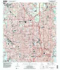
1998 Map of Saint Petersburg
USGS Topo · Published 2001About this map
Saint Petersburg and its neighboring communities of Pinellas Park, Kenneth City, and Gulfport dominate this dense urban landscape at the edge of Tampa Bay and Boca Ciega Bay. The map reveals a highly developed grid of residential streets and arterial roads, punctuated by dozens of educational and religious institutions such as Farragut Academy, St Petersburg Jr College, and St Jude School. The coastal interface is particularly detailed, showing the intricate finger canals of South Causeway Isle and the active waterfront operations at Albert Whitted Airport and the U S Coast Guard Station near Bayboro Harbor.
Find a feature on this map
92 named features on this map. Tap any name to fly to it.
Don’t see what you’re looking for? This feature index may not catch every label — zoom into the map to look around manually.
Map Details
Editions of this 1998 Saint Petersburg Map
This is the sole edition of this map. No revisions or reprints were ever made.
Other maps of this area

1921 · Sand Key
USGS Topo · 1:62,500

1921 · Fort De Soto
USGS Topo · 1:62,500

1921 · St Petersburg
USGS Topo · 1:62,500

1942 · Cockroach Bay
USGS Topo · 1:31,680

1943 · St Petersburg
USGS Topo · 1:31,680

1943 · Gandy Bridge
USGS Topo · 1:31,680

1943 · Pass-A-Grille
USGS Topo · 1:31,680

1943 · Bay Pines
USGS Topo · 1:31,680

1943 · Safety Harbor
USGS Topo · 1:31,680

1943 · Port Tampa
USGS Topo · 1:31,680