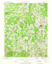
1941 Map of Salem
USGS Topo · Published 1967About this map
The Dent County seat of Salem anchors the eastern edge of this Ozark landscape, mapped during the early 1940s. The region is defined by an intricate network of hollows, such as Elk Hollow, Smoky Hollow, and Jack Hollow, where small settlements like Anutt and Darien established deep roots. A high density of rural institutions suggests a well-distributed population of family farms and homesteads, evidenced by the numerous schools including West Shady Grove Sch and North Whiteoak Sch.
Find a feature on this map
83 named features on this map. Tap any name to fly to it.
Don’t see what you’re looking for? This feature index may not catch every label — zoom into the map to look around manually.
Map Details
Editions of this 1941 Salem Map
2 editions found
Other maps of this area

1912 · Rolla
USGS Topo · 1:62,500

1928 · Meramec Spring
USGS Topo · 1:62,500

1932 · Steelville
USGS Topo · 1:48,000

1932 · Cedar Grove
USGS Topo · 1:48,000

1933 · Steelville
USGS Topo · 1:62,500

1937 · Steelville
USGS Topo · 1:62,500

1937 · Edgar Springs
USGS Topo · 1:48,000

1941 · Salem
USGS Topo · 1:62,500

1941 · Stone Hill
USGS Topo · 1:62,500

1945 · Salem
USGS Topo · 1:62,500