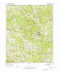
1950 Map of Salem
USGS Topo · Published 1976About this map
Salem sits at the heart of this North Arkansas landscape, serving as a hub for the scattered farming and timber communities of Fulton County. The terrain is defined by the winding paths of the South Fork Spring River and the Strawberry River, which carve through a series of prominent ridges and knobs like Turkey Knob and Wallace Knob. This mid-century survey documents a network of rural schoolhouses and country churches that anchored local life before widespread consolidation, including the Stateline Sch near the Missouri border and the Wesley Chapel to the south. Genealogists can find several family-named landmarks and burial grounds, such as the Cook Cem and Liberty Hill Cem, which dot the hillsides along small waterways like Greasy Creek and Wildcat Creek.
Find a feature on this map
64 named features on this map. Tap any name to fly to it.
Don’t see what you’re looking for? This feature index may not catch every label — zoom into the map to look around manually.
Map Details
Editions of this 1950 Salem Map
2 editions found

Other maps of this area

1890 · Mountain Home
USGS Topo · 1:125,000

1891 · Mountain Home
USGS Topo · 1:125,000

1894 · Mountain Home
USGS Topo · 1:125,000

1943 · Thayer
USGS Topo · 1:62,500

1944 · West Plains
USGS Topo · 1:62,500

1944 · Cureall
USGS Topo · 1:62,500

1945 · Harrison
USGS Topo · 1:250,000

1946 · Thayer
USGS Topo · 1:62,500

1946 · West Plains
USGS Topo · 1:62,500

1946 · Cureall
USGS Topo · 1:62,500