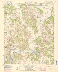
1951 Map of Salem
USGS Topo · Published 1966About this map
Elk River and its major tributary, Shoal Creek, dominate the topography of this Tennessee-Alabama borderlands region as surveyed in the late 1940s and updated in the 1960s. The landscape is defined by the impact of the Tennessee Valley Authority, notably the backwaters of Wheeler Reservoir and the establishment of the Elk River Fish Hatchery near Buck Island. The settlement pattern follows the drainage of various hollows, with family-named landmarks like Gaston Hollow and Horton Hollow providing a sense of historical community boundaries.
Find a feature on this map
84 named features on this map. Tap any name to fly to it.
Don’t see what you’re looking for? This feature index may not catch every label — zoom into the map to look around manually.
Map Details
Editions of this 1951 Salem Map
3 editions found
Other maps of this area

1888 · Huntsville
USGS Topo · 1:125,000

1892 · Huntsville
USGS Topo · 1:125,000

1935 · Athens
USGS Topo · 1:24,000

1936 · Union Hill
USGS Topo · 1:24,000

1936 · Aspen Hill
USGS Topo · 1:24,000

1936 · Elkmont
USGS Topo · 1:24,000

1936 · Ripley
USGS Topo · 1:24,000

1936 · Appleton
USGS Topo · 1:24,000

1936 · Cairo
USGS Topo · 1:24,000

1936 · Elkton
USGS Topo · 1:24,000