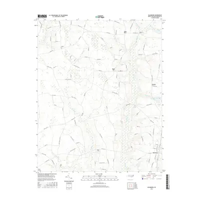
2016 Map of Salemburg
USGS Topo · Published 2016About this map
Salemburg serves as the primary municipal center in this section of Sampson County, characterized by a transition from organized town streets to the expansive coastal plain drainage basins of the Little Coharie Cr and Big Swamp. The landscape is dotted with small, historically significant nodes like Halls Store, Rebel City, and Huntley, reflecting the decentralized rural commerce of the region. Local genealogy is well-represented through family-named landmarks such as Williams Cem, Halls Cem, and Butler Cem, alongside private infrastructure like the Triple F Airpark. Water management and historical industry are evident in features such as Crumpler Millpond and Mathews Pond, while the presence of Piney Pocosin in the southwest indicates the unique boggy terrain typical of the North Carolina tidewater. This network of backroads, including Hayes Mill Rd and Welcome School Rd, connects the scattered farms and homesteads to the established center at Salemburg.
Find a feature on this map
95 named features on this map. Tap any name to fly to it.
Don’t see what you’re looking for? This feature index may not catch every label — zoom into the map to look around manually.
Map Details
Editions of this 2016 Salemburg Map
This is the sole edition of this map. No revisions or reprints were ever made.
Other maps of this area

1909 · Coharie
USGS Topo · 1:62,500

1953 · Florence
USGS Topo · 1:250,000

1953 · Raleigh
USGS Topo · 1:250,000

1954 · Florence
USGS Topo · 1:250,000

1954 · Raleigh
USGS Topo · 1:250,000

1959 · Roseboro
USGS Topo · 1:62,500

1959 · Garland
USGS Topo · 1:62,500

1974 · Salemburg
USGS Topo · 1:24,000
1974 · Wade
USGS Topo · 1:24,000
1974 · Stedman
USGS Topo · 1:24,000