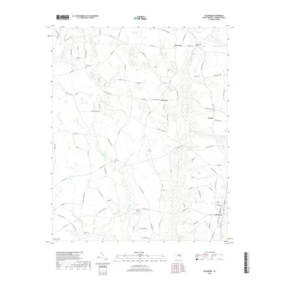
2019 Map of Salemburg
USGS Topo · Published 2019About this map
Salemburg serves as the primary municipal anchor in this portion of Sampson County, where the Coastal Plain landscape is defined by an intricate network of wetlands and slow-moving water. The geography is dominated by Big Swamp and Little Coharie Cr, with significant features like the Piney Pocosin and Dismal Bay illustrating the hydrologic character of the region. This 2019 survey documents a landscape of dispersed agricultural settlements, including Halls Store, Rebel City, and Huntley, connected by a web of rural roads such as Autry Mill Rd and Maxwell Rd. Local family history is preserved through several small burial grounds, including Williams Cem, Halls Cem, and Butler Cem. Significant landmarks of the local economy and infrastructure, such as the Crumpler Millpond and the Triple F Airpark, are clearly identified alongside local crossings like the High House Bridge.
Find a feature on this map
98 named features on this map. Tap any name to fly to it.
Don’t see what you’re looking for? This feature index may not catch every label — zoom into the map to look around manually.
Map Details
Editions of this 2019 Salemburg Map
This is the sole edition of this map. No revisions or reprints were ever made.
Other maps of this area

1909 · Coharie
USGS Topo · 1:62,500

1953 · Florence
USGS Topo · 1:250,000

1953 · Raleigh
USGS Topo · 1:250,000

1954 · Florence
USGS Topo · 1:250,000

1954 · Raleigh
USGS Topo · 1:250,000

1959 · Roseboro
USGS Topo · 1:62,500

1959 · Garland
USGS Topo · 1:62,500

1974 · Salemburg
USGS Topo · 1:24,000
1974 · Wade
USGS Topo · 1:24,000
1974 · Stedman
USGS Topo · 1:24,000