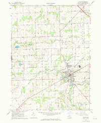
1967 Map of Saline
USGS Topo · Published 1969About this map
The Saline River cuts through the heart of this landscape, anchoring the city of Saline as it appeared in the late 1960s. The map illustrates a period of transition where agriculture and industry intersect, evidenced by the numerous Gravel Pits concentrated near the Ann Arbor RR and Penn Central tracks. Local institutions are well-documented, including the Houghton Sch and Jensen Sch, alongside the specialized Fish Hatchery and Saline Waterworks.
Find a feature on this map
59 named features on this map. Tap any name to fly to it.
Don’t see what you’re looking for? This feature index may not catch every label — zoom into the map to look around manually.
Map Details
Editions of this 1967 Saline Map
3 editions found
Other maps of this area

1902 · South Lyon
USGS Topo · 1:62,500

1902 · Ypsilanti
USGS Topo · 1:62,500

1902 · Dexter
USGS Topo · 1:62,500

1904 · Ann Arbor
USGS Topo · 1:125,000

1906 · Ypsilanti
USGS Topo · 1:62,500

1906 · Dexter
USGS Topo · 1:62,500

1906 · Saline
USGS Topo · 1:62,500

1906 · South Lyon
USGS Topo · 1:62,500

1908 · Ann Arbor
USGS Topo · 1:125,000

1954 · Detroit
USGS Topo · 1:250,000