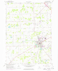
1967 Map of Saline
USGS Topo · Published 1977About this map
The city of Saline serves as the focal point of this mid-1960s study, situated at the convergence of the Saline River and several key transit corridors. The landscape reveals a transition from the developing municipal core to the surrounding agricultural townships of Lodi, Pittsfield, Saline, and York. This era shows significant local infrastructure, including the Ann Arbor Municipal Airport in the northeast and the Saline Waterworks along the river. Genealogists will find several burial sites well-preserved on this sheet, such as Lodi Cem, Union Cem, and Judd Cem. A notable information-gain insight is the presence of an abandoned railroad line cutting through the fields west of the city, marking the end of a previous era of rail commerce while the Trailer Park and suburban expansion north of the river signal modern growth.
Find a feature on this map
68 named features on this map. Tap any name to fly to it.
Don’t see what you’re looking for? This feature index may not catch every label — zoom into the map to look around manually.
Map Details
Editions of this 1967 Saline Map
3 editions found
Other maps of this area

1902 · South Lyon
USGS Topo · 1:62,500

1902 · Ypsilanti
USGS Topo · 1:62,500

1902 · Dexter
USGS Topo · 1:62,500

1904 · Ann Arbor
USGS Topo · 1:125,000

1906 · Ypsilanti
USGS Topo · 1:62,500

1906 · Dexter
USGS Topo · 1:62,500

1906 · Saline
USGS Topo · 1:62,500

1906 · South Lyon
USGS Topo · 1:62,500

1908 · Ann Arbor
USGS Topo · 1:125,000

1954 · Detroit
USGS Topo · 1:250,000