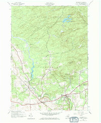
1945 Map of Salisbury
USGS Topo · Published 1969About this map
Spruce Creek and Spruce Lake define the central drainage of this Herkimer County landscape, where the southern boundary of the Adirondack State Park meets a cluster of upland settlements. The map documents a rural network of named intersections and hamlets including Paper Mill Corners, Burrell Corners, and Diamond Hill, which were central to local movement before modern highway expansion. Genealogists will find a high density of rural burial grounds, such as Comstock Cem and St Bridget Cem, alongside landmarks like Kelly Sch. The geography reflects the transition from the forested highlands of Hedgehog Mountain down to the industrialized water resources of the Dolgeville Reservoir and Tuttle Dam, capturing the area's mid-century reliance on its creeks and reservoirs.
Find a feature on this map
35 named features on this map. Tap any name to fly to it.
Don’t see what you’re looking for? This feature index may not catch every label — zoom into the map to look around manually.
Map Details
Editions of this 1945 Salisbury Map
Other maps of this area

1900 · Little Falls
USGS Topo · 1:62,500

1900 · Wilmurt
USGS Topo · 1:62,500

1901 · Lassellsville
USGS Topo · 1:62,500

1902 · Wilmurt
USGS Topo · 1:62,500

1903 · Lassellsville
USGS Topo · 1:62,500

1903 · Little Falls
USGS Topo · 1:62,500

1904 · Piseco Lake
USGS Topo · 1:62,500

1906 · Piseco Lake
USGS Topo · 1:62,500

1908 · Piseco Lake
USGS Topo · 1:62,500

1939 · Little Falls
USGS Topo · 1:62,500