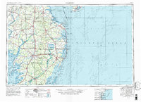
1946 Map of Salisbury
USGS Topo · Published 1981About this map
The Delmarva Peninsula stretches between the Atlantic Ocean and Delaware Bay in this mid-century portrait of Maryland, Delaware, and Virginia. Salisbury serves as a central hub, where the Wicomico River meets a network of vital land routes like U S 13 and U S 50. The landscape is defined by its maritime economy and conservation, featuring the Assateague Island National Seashore and the Chincoteague National Wildlife Refuge. The map captures the region's defense and transit history, from the Fort Miles Military Reservation at Cape Henlopen to the rails of the Penn Central. Inland, the survey details established towns such as Princess Anne and Snow Hill, alongside several state forests including Redden State Forest, illustrating the transition from coastal wetlands to productive timberlands.
Find a feature on this map
218 named features on this map. Tap any name to fly to it.
Don’t see what you’re looking for? This feature index may not catch every label — zoom into the map to look around manually.
Map Details
Editions of this 1946 Salisbury Map
4 editions found

Other maps of this area

1884 · Sea Isle
USGS Topo · 1:62,500

1888 · Cape May
USGS Topo · 1:62,500

1888 · Dennisville
USGS Topo · 1:62,500

1888 · Sea Isle
USGS Topo · 1:62,500

1890 · Maurice Cove
USGS Topo · 1:62,500

1891 · Maurice Cove
USGS Topo · 1:62,500

1893 · Cape May
USGS Topo · 1:62,500

1894 · Dennisville
USGS Topo · 1:62,500

1894 · Sea Isle
USGS Topo · 1:62,500

1898 · Choptank
USGS Topo · 1:125,000