
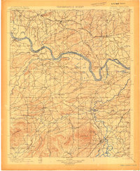
1900 Map of Sallisaw
USGS Topo · Published 1900About this map
The Arkansas River serves as the dividing line between the Cherokee Nation and Choctaw Nation in this detailed survey of the Indian Territory. At the turn of the century, the region's development followed the path of the river and a rapidly expanding rail network, including the St. Louis and San Francisco R. R. and the Kansas City Pittsburg and Gulf R. R.. Major settlements such as Sallisaw and Poteau are established hubs, while smaller river towns like Tamaha and Redland dot the banks.
Find a feature on this map
79 named features on this map. Tap any name to fly to it.
Don’t see what you’re looking for? This feature index may not catch every label — zoom into the map to look around manually.
Map Details
Editions of this 1900 Sallisaw Map
2 editions found
Other maps of this area

1879 · Fort Smith
USGS Topo · 1:62,500

1887 · Van Buren
USGS Topo · 1:62,500

1887 · Poteau Mountain #2
USGS Topo · 1:62,500

1887 · Greenwood
USGS Topo · 1:62,500

1890 · Fort Smith
USGS Topo · 1:125,000

1890 · Poteau Mountain
USGS Topo · 1:125,000

1898 · Winslow #3
USGS Topo · 1:62,500

1898 · Tahlequah
USGS Topo · 1:125,000

1898 · Winslow
USGS Topo · 1:125,000

1899 · Poteau Mountain
USGS Topo · 1:125,000