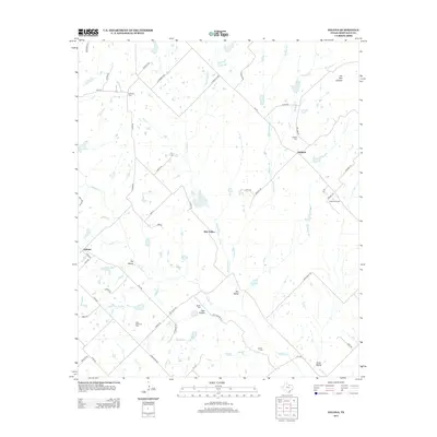
2013 Map of Salona
USGS Topo · Published 2013About this map
Mallard and the surrounding rangeland of Montague County define this landscape, where the headwaters of Denton Cr and its numerous tributaries like Stillhouse Cr and Dry Valley Cr carve a network of drainage across the terrain. This rural area is marked by a scattering of family and community landmarks, including Mitchell Cem, Mallard Cem, and Jackson Cem, which speak to the long-standing settlement of the North Texas prairies. The local economy is tied to the land, evidenced by the Mallard Oil Field and Aries Caddo Oil Field, which punctuate the territory between established routes like FM 455. Higher ground is marked by Jim Ned Lookout in the northeast, overlooking a transition from the narrow draws of Dry Hollow to the broader flats of Jones Valley. The map detail follows the progression of county roads and loops that connect the small centers of Salona and Pole Hollow to the larger regional network.
Find a feature on this map
60 named features on this map. Tap any name to fly to it.
Don’t see what you’re looking for? This feature index may not catch every label — zoom into the map to look around manually.
Map Details
Editions of this 2013 Salona Map
This is the sole edition of this map. No revisions or reprints were ever made.
Other maps of this area

1905 · Montague
USGS Topo · 1:125,000

1954 · Sherman
USGS Topo · 1:250,000

1958 · Sherman
USGS Topo · 1:250,000

1960 · Buzzard Roost Knob
USGS Topo · 1:24,000

1961 · Saint Jo
USGS Topo · 1:24,000

1961 · Salona
USGS Topo · 1:24,000

1961 · New Harp
USGS Topo · 1:24,000

1961 · Montague
USGS Topo · 1:24,000

1961 · Sunset
USGS Topo · 1:24,000
1961 · Smyrna
USGS Topo · 1:24,000