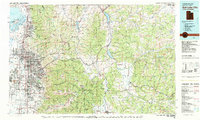
1980 Map of Salt Lake City
USGS Topo · Published 1980About this map
The Wasatch Range dominates this 1980 survey, showing the Salt Lake Valley at a point of significant suburban expansion alongside its deep mining heritage. The dense urban corridors of Salt Lake City, Murray, and Sandy City are clearly defined by an evolving network of freeways, including Interstate 80 and Interstate 215. Eastward, the high peaks of the Wasatch National Forest provide a sharp contrast to the valley floor, hiding a legacy of silver and lead extraction. Historic mining sites like the Ontario Mine, Wasatch Mine, and Mayflower Mine are located near the headwaters of the canyons. The map also traces the vital water infrastructure of the era, from the Jordan River to high-altitude catchments like East Canyon Reservoir and Rockport Lake, while the Union Pacific and Denver and Rio Grande Western railroads continue to navigate the mountain passes.
Find a feature on this map
109 named features on this map. Tap any name to fly to it.
Don’t see what you’re looking for? This feature index may not catch every label — zoom into the map to look around manually.
Map Details
Editions of this 1980 Salt Lake City Map
3 editions found
Other maps of this area

1885 · Salt Lake
USGS Topo · 1:250,000

1885 · Uinta
USGS Topo · 1:250,000

1885 · Tooele Valley
USGS Topo · 1:250,000

1900 · Coalville
USGS Topo · 1:125,000

1901 · Hayden Peak
USGS Topo · 1:125,000

1903 · Hayden Peak
USGS Topo · 1:125,000

1903 · Coalville
USGS Topo · 1:125,000

1907 · Strawberry Valley
USGS Topo · 1:125,000

1909 · Strawberry Valley
USGS Topo · 1:125,000

1915 · Fairfield
USGS Topo · 1:62,500