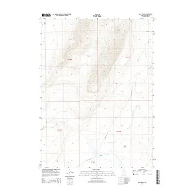
2014 Map of Salt Wells
USGS Topo · Published 2014About this map
Salt Wells Flat dominates the southern reaches of this landscape in Box Elder County, where the desert floor transitions into a network of arid basins. The topography is defined by the broad expanse of Hansel Valley and the smaller Sage Valley to the northwest, illustrating the basin and range structure characteristic of the region. Drainage is carved by the Hansel Valley Wash, a seasonal watercourse that meanders south toward the flats. A primitive transportation network, including Hansel Valley Rd and Salt Wells Rd, follows the natural contours of the valley floors, providing access through this sparsely populated territory. This 2014 survey records the traditional land divisions and remote access routes that have served local ranching and transit for generations.
Find a feature on this map
13 named features on this map. Tap any name to fly to it.
Don’t see what you’re looking for? This feature index may not catch every label — zoom into the map to look around manually.
Map Details
Editions of this 2014 Salt Wells Map
This is the sole edition of this map. No revisions or reprints were ever made.
Other maps of this area

1954 · Brigham City
USGS Topo · 1:250,000

1958 · Brigham City
USGS Topo · 1:250,000

1962 · Brigham City
USGS Topo · 1:250,000

1968 · Lake Ridge
USGS Topo · 1:24,000

1968 · Sunset Pass
USGS Topo · 1:24,000

1968 · Monument Point
USGS Topo · 1:24,000

1968 · Salt Wells
USGS Topo · 1:24,000

1968 · Rattlesnake Pass
USGS Topo · 1:24,000

1968 · Snowville
USGS Topo · 1:24,000
1968 · Bulls Pass
USGS Topo · 1:24,000