
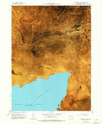
1968 Map of Monument Point
USGS Topo · Published 1969About this map
Hansel Mts rise sharply above the northern reaches of the Great Salt Lake, overlooking a landscape defined by expansive salt flats and early transportation corridors. The 1968 shoreline of Spring Bay meets a series of vast alkaline basins, including Mud Flat and Salt Wells Flat, where geography dictated the path of the First Transcontinental Railroad. Tracing the southern foothills of the mountains, both the Old Central Pacific Grade and the Old Union Pacific Grade traverse the terrain near Monument Point. This alignment reflects the intense competition between the two rail companies as they raced to meet at Promontory, leaving behind parallel earthen works across the desert. Scattered water sources like Pothole Springs and various unnamed salt springs provided critical, if brackish, relief in this arid environment, while Lone Rock stands as a solitary navigational landmark amidst the level flats.
Find a feature on this map
16 named features on this map. Tap any name to fly to it.
Don’t see what you’re looking for? This feature index may not catch every label — zoom into the map to look around manually.
Map Details
Editions of this 1968 Monument Point Map
2 editions found
Other maps of this area

1954 · Brigham City
USGS Topo · 1:250,000

1958 · Brigham City
USGS Topo · 1:250,000

1962 · Brigham City
USGS Topo · 1:250,000

1968 · Rozel
USGS Topo · 1:24,000

1968 · Lake Ridge
USGS Topo · 1:24,000

1968 · Coyote Point
USGS Topo · 1:24,000

1968 · Salt Wells
USGS Topo · 1:24,000

1968 · Monument Peak SW
USGS Topo · 1:24,000

1968 · Monument Peak
USGS Topo · 1:24,000

1969 · Spring Bay SW
USGS Topo · 1:24,000