1968 Map of Lake Ridge
USGS Topo · Published 1969About this map
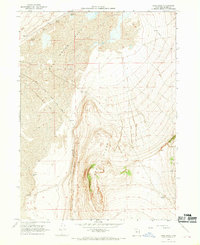
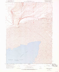
The Old Central Pacific Grade cuts a diagonal path through the northwest corner of this Box Elder County landscape, marking the historic path of the first transcontinental railroad across the Great Salt Lake Desert. In this 1968 field-checked survey, the topography is dominated by the stark contrast between the low-lying Mud Flat and Salt Wells Flat to the west and the rising elevation of Lake Ridge to the east. Water sources are scarce and mineral-heavy, as evidenced by several points labeled Spring (Salt), while Cedar Spring provides a named landmark at the base of the ridge. The presence of a Pipeline and a Gravel Pit indicates the industrial utility of this arid terrain in the late 1960s, while numerous bench marks like BM 4273 provide precise elevation data for the basin floor.
Find a feature on this map
20 named features on this map. Tap any name to fly to it.
Don’t see what you’re looking for? This feature index may not catch every label — zoom into the map to look around manually.
Map Details
Editions of this 1968 Lake Ridge Map
2 editions found

Other maps of this area

1954 · Brigham City
USGS Topo · 1:250,000

1958 · Brigham City
USGS Topo · 1:250,000

1962 · Brigham City
USGS Topo · 1:250,000
1967 · Golden Spike Monument
USGS Topo · 1:24,000
1968 · Rozel
USGS Topo · 1:24,000
1968 · Sunset Pass
USGS Topo · 1:24,000
1968 · Monument Point
USGS Topo · 1:24,000
1968 · Coyote Point
USGS Topo · 1:24,000
1968 · Salt Wells
USGS Topo · 1:24,000
1968 · Bulls Pass
USGS Topo · 1:24,000