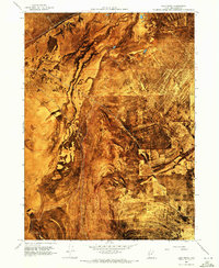
1968 Map of Lake Ridge
USGS Topo · Published 1972About this map
Lake Ridge rises above the expansive salt-crusted terrain of northwestern Utah in this 1968 orthophotomap. The landscape is defined by the stark transition from the high ground of the ridge to the broad, level expanse of the Mud Flat to the west. This area is historically significant as the route of the Old Central Pacific Grade, which cuts diagonally across the salt desert. The presence of several Spring (Salt) locations and a scattered Well highlight the scarce water resources that once dictated survival and transit in this arid environment. A small Gravel Pit near the northern boundary suggests localized material extraction, likely supporting the maintenance of these remote transportation corridors through the Great Salt Lake desert.
Find a feature on this map
12 named features on this map. Tap any name to fly to it.
Don’t see what you’re looking for? This feature index may not catch every label — zoom into the map to look around manually.
Map Details
Editions of this 1968 Lake Ridge Map
2 editions found
Other maps of this area

1954 · Brigham City
USGS Topo · 1:250,000

1958 · Brigham City
USGS Topo · 1:250,000

1962 · Brigham City
USGS Topo · 1:250,000

1967 · Golden Spike Monument
USGS Topo · 1:24,000

1968 · Rozel
USGS Topo · 1:24,000

1968 · Lake Ridge
USGS Topo · 1:24,000

1968 · Sunset Pass
USGS Topo · 1:24,000

1968 · Monument Point
USGS Topo · 1:24,000

1968 · Coyote Point
USGS Topo · 1:24,000

1968 · Salt Wells
USGS Topo · 1:24,000