
1968 Map of Coyote Point
USGS Topo · Published 1969About this map
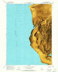
Great Salt Lake waters meet the stark eastern shore of Spring Bay in this late 1960s topographic record. The landscape is dominated by expansive Mud Flat zones and Sand deposits that shift with the fluctuating water levels, which were recorded at an elevation of 4193 feet in November 1966. Rising abruptly from the flats, the terrain climbs toward the summit of Black Mtn, providing a dramatic vertical contrast to the shoreline.
Find a feature on this map
12 named features on this map. Tap any name to fly to it.
Don’t see what you’re looking for? This feature index may not catch every label — zoom into the map to look around manually.
Map Details
Editions of this 1968 Coyote Point Map
2 editions found
Other maps of this area

1954 · Brigham City
USGS Topo · 1:250,000

1958 · Brigham City
USGS Topo · 1:250,000

1962 · Brigham City
USGS Topo · 1:250,000

1968 · Rozel
USGS Topo · 1:24,000

1968 · Lake Ridge
USGS Topo · 1:24,000

1968 · Monument Point
USGS Topo · 1:24,000

1968 · Rozel Point
USGS Topo · 1:24,000

1969 · Spring Bay SW
USGS Topo · 1:24,000
1969 · Gunnison Island NE
USGS Topo · 1:24,000

1969 · Locomotive Springs
USGS Topo · 1:24,000