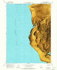
1968 Map of Coyote Point
USGS Topo · Published 1972About this map
Great Salt Lake dominates the western half of this orthophotomap, with the water level recorded at an elevation of 4193 feet as of November 1966. This specific shoreline along Spring Bay reveals the stark interface between the brine and the expansive Mud Flat that defines the eastern terrain. The use of an orthophotomosaic, compiled from 1969 aerial photography, provides an unusually clear view of the salt-crusted geography and the isolated water sources that cling to the edge of the desert. Near the southern end of the sheet, Coyote Point Spring and the adjacent Coyote Ponds mark a rare point of hydrological interest in an otherwise arid expanse. A single unimproved dirt track provides the only overland access through this desolate corner of Box Elder County, crossing the township boundary between T. 10 N. and T. 9 N.
Find a feature on this map
8 named features on this map. Tap any name to fly to it.
Don’t see what you’re looking for? This feature index may not catch every label — zoom into the map to look around manually.
Map Details
Editions of this 1968 Coyote Point Map
2 editions found
Other maps of this area

1954 · Brigham City
USGS Topo · 1:250,000

1958 · Brigham City
USGS Topo · 1:250,000

1962 · Brigham City
USGS Topo · 1:250,000

1968 · Rozel
USGS Topo · 1:24,000

1968 · Lake Ridge
USGS Topo · 1:24,000

1968 · Monument Point
USGS Topo · 1:24,000

1968 · Coyote Point
USGS Topo · 1:24,000

1968 · Rozel Point
USGS Topo · 1:24,000

1969 · Spring Bay SW
USGS Topo · 1:24,000
1969 · Gunnison Island NE
USGS Topo · 1:24,000