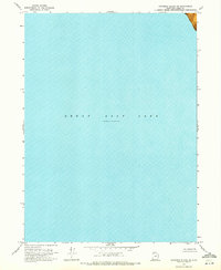
1969 Map of Gunnison Island NE
USGS Topo · Published 1972About this map
Great Salt Lake dominates this 1969 orthophotomosaic, which records a specific hydrologic moment when the water level was measured at Elevation 4193 in November 1966. The map is almost entirely composed of the lake's open water, providing a rare topographic record of the lake bed and shoreline before subsequent fluctuations. In the northeastern corner, a portion of a Mud Flat emerges, illustrating the shallow, shifting margins of the basin in Box Elder County. Compiled from soundings by the U. S. Naval Reserve and the U. S. Corps of Engineers, the survey offers specialized bathymetric data during an era of significant geological study by the Utah Geological and Mineralogical Survey.
Find a feature on this map
3 named features on this map. Tap any name to fly to it.
Don’t see what you’re looking for? This feature index may not catch every label — zoom into the map to look around manually.
Map Details
Editions of this 1969 Gunnison Island NE Map
This is the sole edition of this map. No revisions or reprints were ever made.
Other maps of this area

1954 · Brigham City
USGS Topo · 1:250,000

1958 · Brigham City
USGS Topo · 1:250,000

1962 · Brigham City
USGS Topo · 1:250,000

1968 · Rozel
USGS Topo · 1:24,000

1968 · Coyote Point
USGS Topo · 1:24,000

1968 · Rozel Point
USGS Topo · 1:24,000

1969 · Rozel Point SW
USGS Topo · 1:24,000

1969 · Spring Bay SW
USGS Topo · 1:24,000

1969 · Gunnison Island SW
USGS Topo · 1:24,000

1969 · Gunnison Island
USGS Topo · 1:24,000