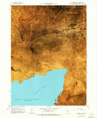
1968 Map of Monument Point
USGS Topo · Published 1972About this map
Monument Point stands as a prominent overlook where the rugged southern reaches of the Hansel Mts meet the expansive Mud Flat of the northern Great Salt Lake basin. This 1968 orthophotomap provides a rare hybrid view of the landscape, combining traditional topographic contours with aerial photography to reveal the stark texture of Spring Bay and the surrounding alkali terrain. A significant historical alignment is visible here: the Old Central Pacific Grade cuts across the flats, tracing the path of the first transcontinental railroad north of the current Union Pacific line. Hydrological features like Pothole Spring and several Salt Springs punctuate the arid environment, while a Gravel Pit near Salt Wells indicates local industrial activity in this sparsely settled portion of Box Elder County.
Find a feature on this map
15 named features on this map. Tap any name to fly to it.
Don’t see what you’re looking for? This feature index may not catch every label — zoom into the map to look around manually.
Map Details
Editions of this 1968 Monument Point Map
2 editions found
Other maps of this area

1954 · Brigham City
USGS Topo · 1:250,000

1958 · Brigham City
USGS Topo · 1:250,000

1962 · Brigham City
USGS Topo · 1:250,000

1968 · Rozel
USGS Topo · 1:24,000

1968 · Lake Ridge
USGS Topo · 1:24,000

1968 · Monument Point
USGS Topo · 1:24,000

1968 · Coyote Point
USGS Topo · 1:24,000

1968 · Salt Wells
USGS Topo · 1:24,000

1968 · Monument Peak SW
USGS Topo · 1:24,000

1968 · Monument Peak
USGS Topo · 1:24,000