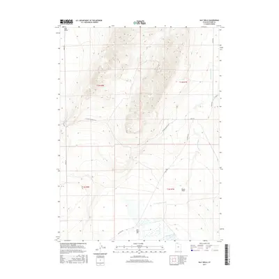
2017 Map of Salt Wells
USGS Topo · Published 2017About this map
Hansel Valley Wash meanders through the central corridor of this northern Utah landscape, a defining drainage for the surrounding basins. The area is characterized by high-elevation valleys and flats, specifically Sage Valley in the northwest and Hansel Valley to the southeast. At the southern end of the sheet, the terrain opens into the Salt Wells Flat, where the namesake Salt Wells settlement is located. This location serves as a critical junction for rural transport, with Salt Wells Rd and W Hansel Mountain Rd N providing access through the rugged foothills. The map reveals a remote, arid environment structured by the Public Land Survey System, including boundaries for t13n r8w and t13n r7w, illustrating the vast, organized spacing of the Great Basin region.
Find a feature on this map
15 named features on this map. Tap any name to fly to it.
Don’t see what you’re looking for? This feature index may not catch every label — zoom into the map to look around manually.
Map Details
Editions of this 2017 Salt Wells Map
This is the sole edition of this map. No revisions or reprints were ever made.
Other maps of this area

1954 · Brigham City
USGS Topo · 1:250,000

1958 · Brigham City
USGS Topo · 1:250,000

1962 · Brigham City
USGS Topo · 1:250,000

1968 · Lake Ridge
USGS Topo · 1:24,000

1968 · Sunset Pass
USGS Topo · 1:24,000

1968 · Monument Point
USGS Topo · 1:24,000

1968 · Salt Wells
USGS Topo · 1:24,000

1968 · Rattlesnake Pass
USGS Topo · 1:24,000

1968 · Snowville
USGS Topo · 1:24,000
1968 · Bulls Pass
USGS Topo · 1:24,000