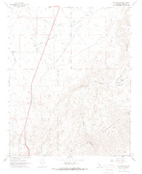
1967 Map of Saltdale NW
USGS Topo · Published 1968About this map
Indian Wells Valley and the northern reaches of the El Paso Mountains dominate this 1967 survey, capturing a landscape defined by industrial extraction and remote desert habitation. The map provides a detailed record of mining operations such as the Cudahy Old Dutch Cleanser Mine and the Copper Basin Mine, alongside the intriguing Burro Schmidts Tunnel. These features, coupled with the Cudahy Camp (Site) and Bickel Camp, suggest a persistent human presence focused on the mineral wealth found within Last Chance Canyon and the surrounding Red Buttes.
Find a feature on this map
26 named features on this map. Tap any name to fly to it.
Don’t see what you’re looking for? This feature index may not catch every label — zoom into the map to look around manually.
Map Details
Editions of this 1967 Saltdale NW Map
3 editions found
Other maps of this area

1906 · Kernville
USGS Topo · 1:125,000

1908 · Kernville
USGS Topo · 1:125,000

1915 · Searles Lake
USGS Topo · 1:250,000

1915 · Mojave
USGS Topo · 1:125,000

1943 · Inyokern
USGS Topo · 1:62,500

1943 · Cross Mountain
USGS Topo · 1:62,500

1943 · Saltdale
USGS Topo · 1:62,500

1943 · Onyx
USGS Topo · 1:62,500

1947 · Trona
USGS Topo · 1:250,000

1948 · Trona
USGS Topo · 1:250,000