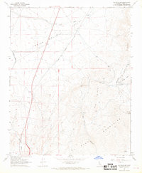
1967 Map of Saltdale NW
USGS Topo · Published 1969About this map
Mining operations and arid land infrastructure dominate this 1967 survey of the High Desert. The El Paso Mountains and Red Buttes provide a backdrop for specialized extraction efforts, most notably the Cudahys Old Dutch Cleanser Mine and the Burro Schmidt Tunnel. These sites, along with the Copper Basin Mine, reflect the mid-century industrial footprint in a landscape defined by deep drainages like Last Chance Canyon and Bonanza Gulch.
Find a feature on this map
28 named features on this map. Tap any name to fly to it.
Don’t see what you’re looking for? This feature index may not catch every label — zoom into the map to look around manually.
Map Details
Editions of this 1967 Saltdale NW Map
3 editions found
Other maps of this area

1906 · Kernville
USGS Topo · 1:125,000

1908 · Kernville
USGS Topo · 1:125,000

1915 · Searles Lake
USGS Topo · 1:250,000

1915 · Mojave
USGS Topo · 1:125,000

1943 · Inyokern
USGS Topo · 1:62,500

1943 · Cross Mountain
USGS Topo · 1:62,500

1943 · Saltdale
USGS Topo · 1:62,500

1943 · Onyx
USGS Topo · 1:62,500

1947 · Trona
USGS Topo · 1:250,000

1948 · Trona
USGS Topo · 1:250,000