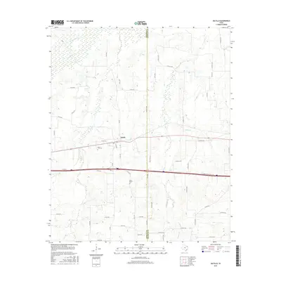
2016 Map of Saltillo
USGS Topo · Published 2016About this map
The community of Saltillo serves as the focal point of this landscape on the boundary of Hopkins and Franklin counties. Bisected by Highway 67 and the modern path of Interstate 30, the area is defined by a dense network of county roads that navigate a terrain carved by numerous drainages. These waterways, including White Oak Cr and Crosstimber Cr in the north and the southward-flowing Stouts Cr, shape the distribution of local homesteads and agricultural plots. For those researching family history, the map provides precise locations for two significant burial grounds: Stouts Creek Cem near the town center and Old Saltillo Cem further south. The drainage patterns of Denton Cr and Greenwood Cr suggest a landscape dominated by riparian corridors and small-scale cattle or farming operations common to this region of East Texas.
Find a feature on this map
58 named features on this map. Tap any name to fly to it.
Don’t see what you’re looking for? This feature index may not catch every label — zoom into the map to look around manually.
Map Details
Editions of this 2016 Saltillo Map
This is the sole edition of this map. No revisions or reprints were ever made.
Other maps of this area

1953 · Texarkana
USGS Topo · 1:250,000

1956 · Texarkana
USGS Topo · 1:250,000

1962 · Sulphur Bluff
USGS Topo · 1:24,000

1963 · Mitchell Creek
USGS Topo · 1:24,000

1964 · Mount Vernon
USGS Topo · 1:24,000

1964 · Saltillo
USGS Topo · 1:24,000

1964 · Hagansport
USGS Topo · 1:24,000

1964 · Como
USGS Topo · 1:24,000

1964 · Purley
USGS Topo · 1:24,000
1965 · New Hope
USGS Topo · 1:24,000