
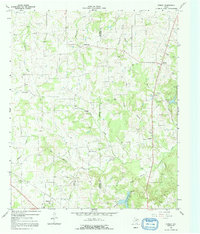
1964 Map of Purley
USGS Topo · Published 1968About this map
Purley and Greenwood anchor the landscape of East Texas along the Hopkins Co Franklin Co line during the mid-1960s. The terrain is defined by a dense network of tributaries including Stouts Creek, Big Cypress Creek, and Little Cypress Creek, which weave between small farming settlements and rural crossroads. The Louisiana and Arkansas railroad cuts through the southwestern corner near Harmony, serving an area marked by early industrial activity such as a Sandpit and scattered Oil Wells.
Find a feature on this map
30 named features on this map. Tap any name to fly to it.
Don’t see what you’re looking for? This feature index may not catch every label — zoom into the map to look around manually.
Map Details
Editions of this 1964 Purley Map
2 editions found
Other maps of this area

1953 · Texarkana
USGS Topo · 1:250,000

1956 · Texarkana
USGS Topo · 1:250,000

1956 · Tyler
USGS Topo · 1:250,000

1960 · Winnsboro
USGS Topo · 1:24,000

1960 · Newsome
USGS Topo · 1:24,000

1960 · Pleasant Grove
USGS Topo · 1:24,000

1964 · Mount Vernon
USGS Topo · 1:24,000

1964 · Saltillo
USGS Topo · 1:24,000

1964 · Como
USGS Topo · 1:24,000
1965 · New Hope
USGS Topo · 1:24,000