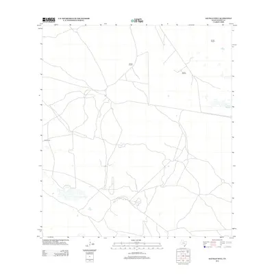
2013 Map of Saltillo Well
USGS Topo · Published 2013About this map
Saltillo Well serves as the focal point for this section of Kenedy County, a landscape defined by the vital infrastructure of South Texas ranching. In this arid coastal plain, water sources are the primary landmarks, evidenced by a network of dispersed windmills that anchor the vast parcels of land. The geography is marked by isolated features such as Borrego Windmill, Chicago Windmill, and Salvador Windmill, which speak to the area's ongoing history of livestock and land management. Near the eastern edge, the wetland depression of Cayo Soledad provides a distinct hydrological contrast to the surrounding scrubland. This 2013 survey illustrates the sparse, functional layout of the region, where a complex web of unimproved roads and 4WD tracks connects these remote outposts, reflecting the specialized demands of working the coastal prairie.
Find a feature on this map
6 named features on this map. Tap any name to fly to it.
Don’t see what you’re looking for? This feature index may not catch every label — zoom into the map to look around manually.
Map Details
Editions of this 2013 Saltillo Well Map
This is the sole edition of this map. No revisions or reprints were ever made.
Other maps of this area

1921 · Tarida Ranch
USGS Topo · 1:62,500

1922 · La Sal Vieja
USGS Topo · 1:62,500

1923 · Armstrong
USGS Topo · 1:62,500

1923 · Saltillo Ranch
USGS Topo · 1:62,500

1953 · Brownsville
USGS Topo · 1:250,000
1956 · Armstrong
USGS Topo · 1:24,000
1956 · San Pedro Ranch
USGS Topo · 1:24,000

1956 · Saltillo Well
USGS Topo · 1:24,000
1956 · Maria Estella Well
USGS Topo · 1:24,000

1956 · Rudolph
USGS Topo · 1:24,000