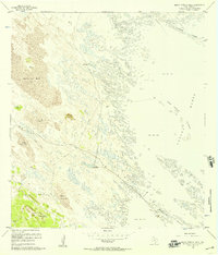
1956 Map of Maria Estella Well
USGS Topo · Published 1957About this map
Artesian wells and long ranch fences define this remote Kenedy County landscape, illustrating the critical infrastructure required for cattle operations in the South Texas coastal sand sheet during the mid-1950s. The presence of the Old Tajos Ranch Windmills and a network of named water sources, including the Maria Estella Artesian Well and Bailadora Artesian Well, highlights the reliance on groundwater in a region dominated by Shifting Sand Dunes. Along the eastern margin, the map documents the transition from these dunes into the Sand and Mud flats of the Laguna Madre. Scattered landforms such as the Calabazas Islands and Tres Marias Islands dot the shallow waters, while the Mesquite Rincon and Rincon Artesian Well mark the interface between the arid ranchland and the coastal lagoon.
Find a feature on this map
17 named features on this map. Tap any name to fly to it.
Don’t see what you’re looking for? This feature index may not catch every label — zoom into the map to look around manually.
Map Details
Editions of this 1956 Maria Estella Well Map
2 editions found
Other maps of this area

1923 · Lopena Island
USGS Topo · 1:62,500

1923 · Saltillo Ranch
USGS Topo · 1:62,500

1928 · Sarita
USGS Topo · 1:125,000

1950 · Corpus Christi
USGS Topo · 1:250,000

1951 · Potrero Lopeno NW
USGS Topo · 1:24,000

1952 · Potrero Cortado
USGS Topo · 1:24,000

1952 · Sarita 4 SE
USGS Topo · 1:24,000

1952 · Potrero Lopeno SW
USGS Topo · 1:24,000

1952 · Potrero Lopeno
USGS Topo · 1:62,500

1953 · Brownsville
USGS Topo · 1:250,000