
1952 Map of Potrero Lopeno SW
USGS Topo · Published 1953About this map
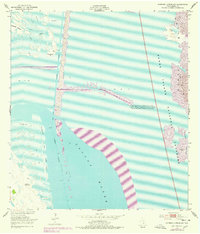
Laguna Madre dominates this 1950s coastal survey, revealing the intricate geography of the Texas shoreline before extensive modern development. The map details a vital maritime corridor, showing the Intracoastal Waterway cutting through the shallow waters between the mainland and the shifting dunes of Padre Island. A series of Spoil Banks line the channel, a direct result of dredging operations to maintain navigable depths. Inland, the landscape of Rincon de San Jose is marked by tidal flats and the Verrendos Artesian Well, indicating the importance of freshwater sources in this saline environment. An isolated Oil Derrick standing in the bay reflects the era's expanding petroleum exploration. The interplay of Sand and Mud across the Mesquite Rincon and Southeast Pt illustrates a dynamic coastal system defined by wind and tide.
Find a feature on this map
13 named features on this map. Tap any name to fly to it.
Don’t see what you’re looking for? This feature index may not catch every label — zoom into the map to look around manually.
Map Details
Editions of this 1952 Potrero Lopeno SW Map
2 editions found
Other maps of this area

1921 · Tarida Ranch
USGS Topo · 1:62,500

1923 · Lopena Island
USGS Topo · 1:62,500

1923 · Saltillo Ranch
USGS Topo · 1:62,500

1951 · South of Potrero Lopeno NE
USGS Topo · 1:24,000

1951 · Potrero Lopeno NW
USGS Topo · 1:24,000

1952 · Potrero Lopeno SE
USGS Topo · 1:24,000

1952 · South of Potrero Lopeno NW
USGS Topo · 1:24,000

1952 · Potrero Lopeno
USGS Topo · 1:62,500

1952 · South of Potrero Lopeno
USGS Topo · 1:62,500

1953 · Brownsville
USGS Topo · 1:250,000