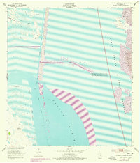
1952 Map of Potrero Lopeno SW
USGS Topo · Published 1978About this map
Laguna Madre dominates this 1952 coastal landscape, revealing the intricate patterns of the Texas shoreline before the full expansion of modern recreational infrastructure. The map highlights the vast Padre Island National Seashore and the slender stretch of Padre Island, defined by shifting sand dunes and mud flats. This survey documents the critical maritime corridor of the Intracoastal Waterway, noting a project depth of 12 feet and a series of Spoil Banks created by maintenance dredging. Inland, the topography shifts to the Rincon De San Jose, where the Verrendos Artesian Well and Mesquite Rincon provide evidence of early water management and land use in this coastal environment. These features illustrate the intersection of natural barrier island migration and the engineered navigational requirements of the mid-20th century.
Find a feature on this map
14 named features on this map. Tap any name to fly to it.
Don’t see what you’re looking for? This feature index may not catch every label — zoom into the map to look around manually.
Map Details
Editions of this 1952 Potrero Lopeno SW Map
2 editions found
Other maps of this area

1921 · Tarida Ranch
USGS Topo · 1:62,500

1923 · Lopena Island
USGS Topo · 1:62,500

1923 · Saltillo Ranch
USGS Topo · 1:62,500

1951 · South of Potrero Lopeno NE
USGS Topo · 1:24,000

1951 · Potrero Lopeno NW
USGS Topo · 1:24,000

1952 · Potrero Lopeno SE
USGS Topo · 1:24,000

1952 · South of Potrero Lopeno NW
USGS Topo · 1:24,000

1952 · Potrero Lopeno SW
USGS Topo · 1:24,000

1952 · Potrero Lopeno
USGS Topo · 1:62,500

1952 · South of Potrero Lopeno
USGS Topo · 1:62,500