1952 Map of South of Potrero Lopeno
USGS Topo · Published 1957About this map
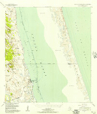
The settlement at Port Mansfield stands as the primary hub on this coastal landscape, situated along the edge of the Laguna Madre and protected by the long stretch of Padre Island. Inland, the terrain is defined by an extensive series of artesian wells and named water points such as Mujeres Wells, El Medio Wells, and Agua Gorda Well, reflecting the critical importance of reliable water sources in this salt-swept ranching environment.
Find a feature on this map
57 named features on this map. Tap any name to fly to it.
Don’t see what you’re looking for? This feature index may not catch every label — zoom into the map to look around manually.
Map Details
Editions of this 1952 South of Potrero Lopeno Map
2 editions found
Historical Maps of Port Mansfield Through Time
191 maps found

1921 Tarida Ranch
Kenedy County, TX

1922 La Sal Vieja
Kenedy County, TX

1923 Armstrong
Kenedy County, TX

1923 Lopena Island
Kenedy County, TX

1923 Saltillo Ranch
Kenedy County, TX

1951 La Parra Ranch NE
Kenedy County, TX

1951 Potrero Lopeno NW
Kenedy County, TX

1951 South of Potrero Lopeno NE
Kenedy County, TX

1952 La Parra Ranch
Kenedy County, TX

1952 La Parra Ranch SE
Kenedy County, TX

1952 Potrero Cortado
Kenedy County, TX

1952 Potrero Lopeno
Kenedy County, TX

1952 Potrero Lopeno SE
Kenedy County, TX

1952 Potrero Lopeno SW
Kenedy County, TX

1952 South of Potrero Lopeno
Kenedy County, TX

1952 South of Potrero Lopeno NW
Kenedy County, TX

1952 Yarborough Pass
Kenedy County, TX

1954 La Parra Ranch SW
Kenedy County, TX

1955 La Parra Ranch
Kenedy County, TX

1955 Potrero Cortado
Kenedy County, TX

1956 Andrea Ranch
Kenedy County, TX

1956 Armstrong
Kenedy County, TX

1956 Armstrong
Kenedy County, TX

1956 Julian
Kenedy County, TX

1956 La Sal Vieja
Kenedy County, TX

1956 Los Amigos Windmill
Kenedy County, TX

1956 Maria Estella Well
Kenedy County, TX

1956 Norias
Kenedy County, TX

1956 Pita Camp
Kenedy County, TX

1956 Rosita Lake
Kenedy County, TX

1956 Rosita Lake
Kenedy County, TX

1956 Rosita Lake NE
Kenedy County, TX

1956 Rudolph
Kenedy County, TX

1956 Saltillo Ranch
Kenedy County, TX

1956 Saltillo Well
Kenedy County, TX

1956 San Pedro Ranch
Kenedy County, TX

1979 La Paloma Ranch
Kenedy County, TX

1979 Sarita SW
Kenedy County, TX

1984 Baffin Bay
Kenedy County, TX

2010 Andrea Ranch
Kenedy County, TX

2010 Armstrong
Kenedy County, TX

2010 Julian
Kenedy County, TX

2010 La Paloma Ranch
Kenedy County, TX

2010 La Parra Ranch
Kenedy County, TX

2010 La Parra Ranch NE
Kenedy County, TX

2010 La Parra Ranch SE
Kenedy County, TX

2010 La Parra Ranch SW
Kenedy County, TX

2010 Los Amigos Windmill
Kenedy County, TX

2010 Maria Estella Well
Kenedy County, TX

2010 Norias
Kenedy County, TX

2010 Pita Camp
Kenedy County, TX

2010 Potrero Cortado
Kenedy County, TX

2010 Potrero Cortado OE E
Kenedy County, TX

2010 Potrero Lopeno NW
Kenedy County, TX

2010 Potrero Lopeno NW OE E
Kenedy County, TX

2010 Potrero Lopeno SE
Kenedy County, TX

2010 Potrero Lopeno SW
Kenedy County, TX

2010 Rosita Lake
Kenedy County, TX

2010 Rosita Lake NE
Kenedy County, TX

2010 Rudolph
Kenedy County, TX

2010 Saltillo Well
Kenedy County, TX

2010 San Pedro Ranch
Kenedy County, TX

2010 Sarita SW
Kenedy County, TX

2010 South of Potrero Lopeno NE
Kenedy County, TX

2010 South of Potrero Lopeno NW
Kenedy County, TX

2010 Turcotte
Kenedy County, TX

2010 Yarborough Pass
Kenedy County, TX

2010 Yarborough Pass OE E
Kenedy County, TX

2013 Andrea Ranch
Kenedy County, TX

2013 Armstrong
Kenedy County, TX

2013 Julian
Kenedy County, TX

2013 La Paloma Ranch
Kenedy County, TX

2013 La Parra Ranch
Kenedy County, TX

2013 La Parra Ranch NE
Kenedy County, TX

2013 La Parra Ranch SE
Kenedy County, TX

2013 La Parra Ranch SW
Kenedy County, TX

2013 Los Amigos Windmill
Kenedy County, TX

2013 Maria Estella Well
Kenedy County, TX

2013 Norias
Kenedy County, TX

2013 Pita Camp
Kenedy County, TX

2013 Potrero Cortado
Kenedy County, TX

2013 Potrero Cortado OE E
Kenedy County, TX

2013 Potrero Lopeno NW
Kenedy County, TX

2013 Potrero Lopeno NW OE E
Kenedy County, TX

2013 Potrero Lopeno SE
Kenedy County, TX

2013 Potrero Lopeno SW
Kenedy County, TX

2013 Rosita Lake
Kenedy County, TX

2013 Rosita Lake NE
Kenedy County, TX

2013 Rudolph
Kenedy County, TX

2013 Saltillo Well
Kenedy County, TX

2013 San Pedro Ranch
Kenedy County, TX

2013 Sarita SW
Kenedy County, TX

2013 South of Potrero Lopeno NE
Kenedy County, TX

2013 South of Potrero Lopeno NW
Kenedy County, TX

2013 Turcotte
Kenedy County, TX

2013 Yarborough Pass
Kenedy County, TX

2013 Yarborough Pass OE E
Kenedy County, TX

2016 Andrea Ranch
Kenedy County, TX

2016 Armstrong
Kenedy County, TX

2016 Julian
Kenedy County, TX

2016 La Paloma Ranch
Kenedy County, TX

2016 La Parra Ranch
Kenedy County, TX

2016 La Parra Ranch NE
Kenedy County, TX

2016 La Parra Ranch SE
Kenedy County, TX

2016 La Parra Ranch SW
Kenedy County, TX

2016 Los Amigos Windmill
Kenedy County, TX

2016 Maria Estella Well
Kenedy County, TX

2016 Norias
Kenedy County, TX

2016 Pita Camp
Kenedy County, TX

2016 Potrero Cortado
Kenedy County, TX

2016 Potrero Cortado OE E
Kenedy County, TX

2016 Potrero Lopeno NW
Kenedy County, TX

2016 Potrero Lopeno NW OE E
Kenedy County, TX

2016 Potrero Lopeno SE
Kenedy County, TX

2016 Potrero Lopeno SW
Kenedy County, TX

2016 Rosita Lake
Kenedy County, TX

2016 Rosita Lake NE
Kenedy County, TX

2016 Rudolph
Kenedy County, TX

2016 Saltillo Well
Kenedy County, TX

2016 San Pedro Ranch
Kenedy County, TX

2016 Sarita SW
Kenedy County, TX

2016 South of Potrero Lopeno NE
Kenedy County, TX

2016 South of Potrero Lopeno NW
Kenedy County, TX

2016 Turcotte
Kenedy County, TX

2016 Yarborough Pass
Kenedy County, TX

2016 Yarborough Pass OE E
Kenedy County, TX

2019 Andrea Ranch
Kenedy County, TX

2019 Armstrong
Kenedy County, TX

2019 Julian
Kenedy County, TX

2019 La Paloma Ranch
Kenedy County, TX

2019 La Parra Ranch
Kenedy County, TX

2019 La Parra Ranch NE
Kenedy County, TX

2019 La Parra Ranch SE
Kenedy County, TX

2019 La Parra Ranch SW
Kenedy County, TX

2019 Los Amigos Windmill
Kenedy County, TX

2019 Maria Estella Well
Kenedy County, TX

2019 Norias
Kenedy County, TX

2019 Pita Camp
Kenedy County, TX

2019 Potrero Cortado
Kenedy County, TX

2019 Potrero Cortado OE E
Kenedy County, TX

2019 Potrero Lopeno NW
Kenedy County, TX

2019 Potrero Lopeno NW OE E
Kenedy County, TX

2019 Potrero Lopeno SE
Kenedy County, TX

2019 Potrero Lopeno SW
Kenedy County, TX

2019 Rosita Lake
Kenedy County, TX

2019 Rosita Lake NE
Kenedy County, TX

2019 Rudolph
Kenedy County, TX

2019 Saltillo Well
Kenedy County, TX

2019 San Pedro Ranch
Kenedy County, TX

2019 Sarita SW
Kenedy County, TX

2019 South of Potrero Lopeno NE
Kenedy County, TX

2019 South of Potrero Lopeno NW
Kenedy County, TX

2019 Turcotte
Kenedy County, TX

2019 Yarborough Pass
Kenedy County, TX

2019 Yarborough Pass OE E
Kenedy County, TX

2022 Andrea Ranch
Kenedy County, TX

2022 Armstrong
Kenedy County, TX

2022 Julian
Kenedy County, TX

2022 La Paloma Ranch
Kenedy County, TX

2022 La Parra Ranch
Kenedy County, TX

2022 La Parra Ranch NE
Kenedy County, TX

2022 La Parra Ranch SE
Kenedy County, TX

2022 La Parra Ranch SW
Kenedy County, TX

2022 Los Amigos Windmill
Kenedy County, TX

2022 Maria Estella Well
Kenedy County, TX

2022 Norias
Kenedy County, TX

2022 Pita Camp
Kenedy County, TX

2022 Potrero Cortado
Kenedy County, TX

2022 Potrero Cortado OE E
Kenedy County, TX

2022 Potrero Lopeno NW
Kenedy County, TX

2022 Potrero Lopeno NW OE E
Kenedy County, TX

2022 Potrero Lopeno SE
Kenedy County, TX

2022 Potrero Lopeno SW
Kenedy County, TX

2022 Rosita Lake
Kenedy County, TX

2022 Rosita Lake NE
Kenedy County, TX

2022 Rudolph
Kenedy County, TX

2022 Saltillo Well
Kenedy County, TX

2022 San Pedro Ranch
Kenedy County, TX

2022 Sarita SW
Kenedy County, TX

2022 South of Potrero Lopeno NE
Kenedy County, TX

2022 South of Potrero Lopeno NW
Kenedy County, TX

2022 Turcotte
Kenedy County, TX

2022 Yarborough Pass
Kenedy County, TX

2022 Yarborough Pass OE E
Kenedy County, TX

2025 Potrero Cortado
Kenedy County, TX

2025 Potrero Cortado OE E
Kenedy County, TX

2025 Potrero Lopeno NW
Kenedy County, TX

2025 Potrero Lopeno NW OE E
Kenedy County, TX

2025 Potrero Lopeno SE
Kenedy County, TX

2025 South of Potrero Lopeno NE
Kenedy County, TX

2025 Yarborough Pass OE E
Kenedy County, TX