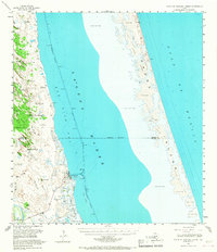
1952 Map of South of Potrero Lopeno
USGS Topo · Published 1968About this map
The coastal waters of the Laguna Madre and the Gulf of Mexico dominate this 1952 topographic study of the South Texas shoreline. Along the western shore, the developing maritime outpost of Port Mansfield is shown with its protected harbor and adjacent Landing Field, serving as a vital link between the mainland and the Intracoastal Waterway. The landscape is defined by its reliance on subterranean water sources, evidenced by a dense network of family-named artesian wells such as Mascal Artesian Well, Mota Mesquite Well, and Aqua Gorda Well scattered across the coastal plains. Eastward across the lagoon, the shifting sands of Padre Island form a barrier of dunes reaching elevations up to 66 feet, while El Sauz Island sits amidst the Spoil Banks created by channel dredging. This survey captures the transition from a traditional ranching economy to one increasingly shaped by modern coastal infrastructure.
Find a feature on this map
51 named features on this map. Tap any name to fly to it.
Don’t see what you’re looking for? This feature index may not catch every label — zoom into the map to look around manually.
Map Details
Editions of this 1952 South of Potrero Lopeno Map
2 editions found

Other maps of this area

1921 · Tarida Ranch
USGS Topo · 1:62,500

1923 · Lopena Island
USGS Topo · 1:62,500

1923 · Saltillo Ranch
USGS Topo · 1:62,500

1951 · South of Potrero Lopeno NE
USGS Topo · 1:24,000

1952 · Green Island
USGS Topo · 1:24,000

1952 · Potrero Lopeno SE
USGS Topo · 1:24,000

1952 · South of Potrero Lopeno NW
USGS Topo · 1:24,000
1952 · North Of Port Isabel NW
USGS Topo · 1:24,000

1952 · South of Potrero Lopeno SE
USGS Topo · 1:24,000

1952 · Hawk Island
USGS Topo · 1:24,000