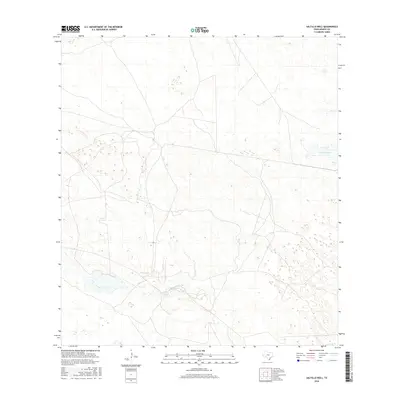
2016 Map of Saltillo Well
USGS Topo · Published 2016About this map
Saltillo Well serves as a vital water source and landmark in this sparsely populated stretch of Kenedy County. The landscape is defined by its low-lying hydrology, where ephemeral pools and marshy depressions are common across the sandy coastal plains. This 2016 survey illustrates a largely undeveloped ranchland environment where naming conventions are focused on essential water points and drainage features. The presence of Cayo Soledad in the eastern portion of the quadrangle highlights the complex network of tidal or brackish water inlets characteristic of this South Texas region. The map reveals the intricate patterns of the natural terrain, showing how very slight changes in elevation dictate the flow of water and the distribution of vegetation in an area where human infrastructure is limited to primitive roads and basic ranch improvements.
Find a feature on this map
2 named features on this map. Tap any name to fly to it.
Don’t see what you’re looking for? This feature index may not catch every label — zoom into the map to look around manually.
Map Details
Editions of this 2016 Saltillo Well Map
This is the sole edition of this map. No revisions or reprints were ever made.
Other maps of this area

1921 · Tarida Ranch
USGS Topo · 1:62,500

1922 · La Sal Vieja
USGS Topo · 1:62,500

1923 · Armstrong
USGS Topo · 1:62,500

1923 · Saltillo Ranch
USGS Topo · 1:62,500

1953 · Brownsville
USGS Topo · 1:250,000
1956 · Armstrong
USGS Topo · 1:24,000
1956 · San Pedro Ranch
USGS Topo · 1:24,000

1956 · Saltillo Well
USGS Topo · 1:24,000
1956 · Maria Estella Well
USGS Topo · 1:24,000

1956 · Rudolph
USGS Topo · 1:24,000