
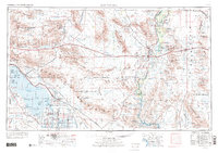
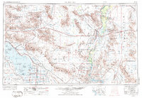
1959 Map of Salton Sea
USGS Topo · Published 1973About this map
The Colorado River and the Salton Sea anchor this desert landscape, where massive irrigation projects like the Coachella Canal and East Highline Canal fueled agricultural development in the Imperial and Palo Verde valleys. The mid-century map captures a region deeply defined by its natural resources and military strategic value. Industrial sites like the Eagle Mountain Mine and the Iron Chief Mine illustrate the scale of extraction in the Chuckwalla Mountains, while vast areas are dedicated to federal use, including the Chocolate Mountain Aerial Gunnery Range and the Yuma Proving Ground. Small transit hubs like Desert Center and Chiriaco Summit punctuate the arid basins, serving as critical stops for travelers and miners alike between the lush riverbanks of Blythe and the growing shores of Salton Sea State Park.
Find a feature on this map
201 named features on this map. Tap any name to fly to it.
Don’t see what you’re looking for? This feature index may not catch every label — zoom into the map to look around manually.
Map Details
Editions of this 1959 Salton Sea Map
4 editions found

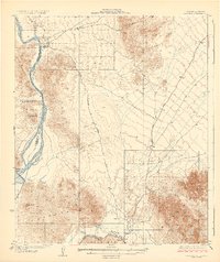
Other maps of this area

1903 · Yuma
USGS Topo · 1:125,000

1904 · Indio
USGS Topo · 1:125,000

1905 · Yuma
USGS Topo · 1:125,000

1907 · Holtville
USGS Topo · 1:125,000

1911 · Parker
USGS Topo · 1:125,000

1915 · El Centro
USGS Topo · 1:125,000

1923 · Signal
USGS Topo · 1:250,000

1928 · Norton
USGS Topo · 1:62,500
1929 · Laguna
USGS Topo · 1:62,500

1929 · Norton
USGS Topo · 1:62,500