Loading...
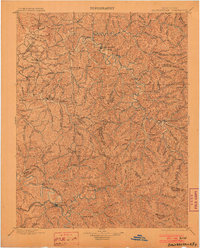
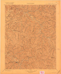
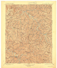
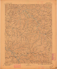
Loading map...1899 Map of Salyersville
USGS Topo · Published 1903About this map
The Licking river and its winding tributaries define this turn-of-the-century landscape across Magoffin, Morgan, and Wolfe counties. This late 19th-century survey documents the eastern Kentucky highlands when travel followed the narrow hollows and ridge lines between established county seats like Salyersville and West Liberty. The map reveals a dense network of small communities, such as Maytown, Ezel, and Hazel Green, which served as local hubs before modern highway development changed the region's accessibility.
Find a feature on this map
124 named features on this map. Tap any name to fly to it.
Don’t see what you’re looking for? This feature index may not catch every label — zoom into the map to look around manually.
Map Details
Date Portrayed1899
Date Published1903
PublisherU.S. Geological Survey
Map TypeTopographic
Scale1:125,000
Physical Dimensions16.2 x 20.1 inches
Editions of this 1899 Salyersville Map
4 editions found

Historical Maps of West Liberty Through Time
3 maps found

Featured Locations
Source Details
SourceU.S. Geological Survey
CopyrightPublic Domain