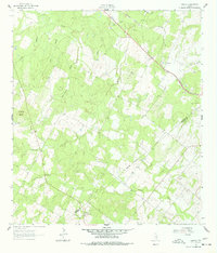
1961 Map of Sample
USGS Topo · Published 1978About this map
The Southern Pacific railroad cuts a diagonal path through this South Texas landscape, anchoring the small settlement of Sample. Located on the border of Gonzales and DeWitt counties, the area is defined by a dense network of seasonal waterways like Shoats Creek and Rocky Creek that feed into the larger Sandies Creek system. The topography is marked by several low elevations, most notably Van Cleave Mound in the west, while the local economy is evidenced by multiple quarries and gravel pits scattered near the rail line.
Find a feature on this map
22 named features on this map. Tap any name to fly to it.
Don’t see what you’re looking for? This feature index may not catch every label — zoom into the map to look around manually.
Map Details
Editions of this 1961 Sample Map
Other maps of this area

1920 · Smiley
USGS Topo · 1:125,000

1953 · Seguin
USGS Topo · 1:250,000

1958 · Seguin
USGS Topo · 1:250,000

1960 · Blackwell Lake
USGS Topo · 1:24,000

1960 · Cheapside
USGS Topo · 1:24,000

1960 · Westhoff
USGS Topo · 1:24,000

1961 · Sample
USGS Topo · 1:24,000
1961 · Pilgrim
USGS Topo · 1:24,000

1961 · New Davy
USGS Topo · 1:24,000
1962 · Smiley
USGS Topo · 1:24,000