
1960 Map of Cheapside
USGS Topo · Published 1962About this map
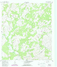
Cheapside serves as the primary settlement hub in this 1960 survey of the rural borderlands between Gonzales and De Witt Counties. The landscape is defined by a dendritic network of seasonal waterways and lowlands, notably Sudberry Creek, Brushy Creek, and the more prominent Sandies Creek to the south. Distinctive hydrological features like Five Mile Lake and Hickory Lake dot the terrain, alongside several areas marked as Salt Flat, suggesting a unique soil composition or history of brackish runoff in the region.
Find a feature on this map
14 named features on this map. Tap any name to fly to it.
Don’t see what you’re looking for? This feature index may not catch every label — zoom into the map to look around manually.
Map Details
Editions of this 1960 Cheapside Map
2 editions found
Other maps of this area

1920 · Smiley
USGS Topo · 1:125,000

1953 · Seguin
USGS Topo · 1:250,000

1958 · Seguin
USGS Topo · 1:250,000

1959 · Cost
USGS Topo · 1:24,000

1959 · Hochheim
USGS Topo · 1:24,000

1959 · Gonzales South
USGS Topo · 1:24,000

1959 · Hamon
USGS Topo · 1:24,000

1960 · Concrete
USGS Topo · 1:24,000

1960 · Westhoff
USGS Topo · 1:24,000

1961 · Sample
USGS Topo · 1:24,000