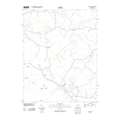
2010 Map of Samuels
USGS Topo · Published 2010About this map
Salt River defines the northern edge of this landscape, where the meandering drainage networks of Cox Creek and Wilson Creek carve a series of ridges and hollows. Small, dispersed settlements like Brownington, Deatsville, and Henpeck are connected by a web of local roads, reflecting a rural Kentucky topography shaped by generations of agriculture and small-scale industry. The map captures a moment in the early 21st century before modern development significantly altered these traditional community boundaries.
Find a feature on this map
72 named features on this map. Tap any name to fly to it.
Don’t see what you’re looking for? This feature index may not catch every label — zoom into the map to look around manually.
Map Details
Editions of this 2010 Samuels Map
This is the sole edition of this map. No revisions or reprints were ever made.
Other maps of this area

1907 · Louisville
USGS Topo · 1:62,500

1929 · Taylorsville
USGS Topo · 1:62,500

1949 · Cravens
USGS Topo · 1:24,000

1949 · Shepherdsville
USGS Topo · 1:24,000

1949 · Samuels
USGS Topo · 1:24,000

1949 · Shepherdsville
USGS Topo · 1:62,500

1951 · Waterford
USGS Topo · 1:24,000
1951 · Brooks
USGS Topo · 1:24,000

1951 · Mount Washington
USGS Topo · 1:24,000
1951 · Louisville
USGS Topo · 1:62,500