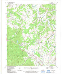
1991 Map of Samuels
USGS Topo · Published 1992About this map
The Bullitt and Nelson County line cuts through this section of Kentucky, where the landscape transitions from the winding Salt River in the north to a series of deeply etched hollows and ridges. The rail corridor in the southeast serves as a focal point for the communities of Samuels and Deatsville, where the local infrastructure includes St Gregorys Church and St Gregorys School. This 1980s-era field check documents a rural pattern of small settlements like Brownington and Lotus connected by winding roads such as Woodsage Road.
Find a feature on this map
41 named features on this map. Tap any name to fly to it.
Don’t see what you’re looking for? This feature index may not catch every label — zoom into the map to look around manually.
Map Details
Editions of this 1991 Samuels Map
This is the sole edition of this map. No revisions or reprints were ever made.
Other maps of this area

1907 · Louisville
USGS Topo · 1:62,500

1929 · Taylorsville
USGS Topo · 1:62,500

1949 · Cravens
USGS Topo · 1:24,000

1949 · Shepherdsville
USGS Topo · 1:24,000

1949 · Samuels
USGS Topo · 1:24,000

1949 · Shepherdsville
USGS Topo · 1:62,500

1951 · Waterford
USGS Topo · 1:24,000
1951 · Brooks
USGS Topo · 1:24,000

1951 · Mount Washington
USGS Topo · 1:24,000
1951 · Louisville
USGS Topo · 1:62,500