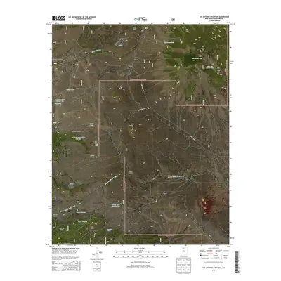
2013 Map of San Antonio Mountain
USGS Topo · Published 2013About this map
San Antonio Mtn dominates this high-altitude landscape within the Carson National Forest, its volcanic profile rising above the surrounding high plains and canyons. The map documents a complex system of water management in an arid environment, where named tanks like Stanley Tank and San Antonio Tank supplement natural features such as Ursulo Lake and the Rio San Antonio. These water sources are essential for the livestock operations evidenced by Stewart Corral and Pole Corral in the northwest, near the open expanse of Stewart Meadows. In the south, the terrain becomes more broken, defined by the winding course of the Arroyo Aguaje de la Petaca and prominent landmarks like Red Hill and Lamy Peak. The presence of Cisneros Park and various family-named canyons, such as Montoya Canyon and Malette Canyon, reflects the long history of land usage and seasonal grazing in this part of Rio Arriba County.
Find a feature on this map
39 named features on this map. Tap any name to fly to it.
Don’t see what you’re looking for? This feature index may not catch every label — zoom into the map to look around manually.
Map Details
Editions of this 2013 San Antonio Mountain Map
This is the sole edition of this map. No revisions or reprints were ever made.
Other maps of this area

1918 · Tusas
USGS Topo · 1:125,000

1954 · Raton
USGS Topo · 1:250,000

1954 · Aztec
USGS Topo · 1:250,000

1958 · Raton
USGS Topo · 1:250,000

1958 · Aztec
USGS Topo · 1:250,000

1962 · Aztec
USGS Topo · 1:250,000
1963 · Los Pinos
USGS Topo · 1:24,000
1963 · Bighorn Peak
USGS Topo · 1:24,000

1963 · Pinabetoso Peaks
USGS Topo · 1:24,000

1963 · Broke Off Mountain
USGS Topo · 1:24,000