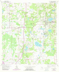
1954 Map of San Antonio
USGS Topo · Published 1988About this map
San Antonio and the nearby settlement of St Leo serve as the primary hubs in this mid-century survey of eastern Pasco County. The landscape is defined by an intricate network of wetlands and water bodies, including Clear Lake and the marshy expanses of the Prairie and Cypress. Family and community history is anchored by several rural landmarks such as Amelia Church, Alliance Church, and St Joseph Cemetery, which point to the established Catholic and local pioneer roots of the region.
Find a feature on this map
26 named features on this map. Tap any name to fly to it.
Don’t see what you’re looking for? This feature index may not catch every label — zoom into the map to look around manually.
Map Details
Editions of this 1954 San Antonio Map
4 editions found
Other maps of this area

1943 · Lutz
USGS Topo · 1:24,000

1944 · Wesley Chapel
USGS Topo · 1:31,680

1944 · Lutz
USGS Topo · 1:31,680

1947 · Zephyrhills
USGS Topo · 1:24,000

1954 · Spring Lake
USGS Topo · 1:24,000

1954 · Ehren
USGS Topo · 1:24,000

1954 · San Antonio
USGS Topo · 1:24,000

1954 · Masaryktown
USGS Topo · 1:24,000

1955 · Plant City
USGS Topo · 1:250,000

1958 · Plant City
USGS Topo · 1:250,000