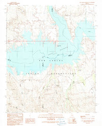
1989 Map of San Carlos Reservoir
USGS Topo · Published 1990About this map
San Carlos Reservoir dominates the landscape of the San Carlos Indian Reservation in this detailed survey of the high desert terrain. The impounded waters of the Gila River reach into various canyons and draws, such as Cottonwood Canyon and Chittakow Draw, while the Coolidge Dam Road traces the southern rim. Of particular interest to historians is the Old Indian Treaty Boundary cutting across the southwestern corner near Mount Geronimo and Rockhouse Mountain. The map records essential water sources in this arid environment, including Wire Corral Spring, Cottonwood Spring, and several named wells like Starlight Well and Gunter Well. Landmarks like Old San Carlos Point and Flatiron Mesa provide topographical orientation for the desert landscape before the 1990s.
Find a feature on this map
27 named features on this map. Tap any name to fly to it.
Don’t see what you’re looking for? This feature index may not catch every label — zoom into the map to look around manually.
Map Details
Editions of this 1989 San Carlos Reservoir Map
This is the sole edition of this map. No revisions or reprints were ever made.
Other maps of this area

1915 · Christmas
USGS Topo · 1:62,500

1917 · Christmas
USGS Topo · 1:62,500

1954 · Mesa
USGS Topo · 1:250,000

1957 · Mesa
USGS Topo · 1:250,000

1958 · Mesa
USGS Topo · 1:250,000

1960 · Mesa
USGS Topo · 1:250,000

1962 · San Carlos Reservoir
USGS Topo · 1:62,500

1964 · Mesa
USGS Topo · 1:250,000

1965 · Bucket Mtn
USGS Topo · 1:24,000
1966 · Mount Triplet
USGS Topo · 1:24,000