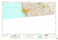
1958 Map of San Diego
USGS Topo · Published 1965About this map
The coastal shelf of San Diego and its mountainous backcountry are captured here just as the post-war suburban boom was reshaping Southern California. The urban core around San Diego Bay and National City is balanced by a massive military footprint, including Miramar NAS, NAS North Island, and the Camp Elliott Naval Reservation. Beyond the growing residential tracts of La Mesa and El Cajon, the landscape rises sharply into the Cleveland National Forest, where high-elevation landmarks like Cuyamaca Peak watch over a network of vital water resources including El Capitan Reservoir and Barrett Lake.
Find a feature on this map
80 named features on this map. Tap any name to fly to it.
Don’t see what you’re looking for? This feature index may not catch every label — zoom into the map to look around manually.
Map Details
Editions of this 1958 San Diego Map
4 editions found

Other maps of this area

1893 · El Cajon
USGS Topo · 1:62,500

1893 · Oceanside
USGS Topo · 1:62,500

1893 · Escondido
USGS Topo · 1:62,500

1898 · Oceanside
USGS Topo · 1:62,500

1901 · Elcajon
USGS Topo · 1:62,500

1901 · Escondido
USGS Topo · 1:62,500

1901 · Oceanside
USGS Topo · 1:62,500

1901 · San Luis Rey
USGS Topo · 1:125,000

1902 · Capistrano
USGS Topo · 1:125,000

1903 · Cuyamaca
USGS Topo · 1:125,000