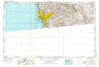
1958 Map of San Diego
USGS Topo · Published 1973About this map
San Diego Bay and the surrounding coastline anchor this mid-century portrait of a region undergoing rapid post-war expansion. The urban footprint of San Diego is already extensive, stretching from the San Diego Lighthouse at Point Loma inland toward La Mesa and El Cajon. A heavy military and educational presence is evident through landmarks like Miramar Naval Air Station, the University of San Diego, and the Border Field Naval Reservation on the United States-Mexico border.
Find a feature on this map
122 named features on this map. Tap any name to fly to it.
Don’t see what you’re looking for? This feature index may not catch every label — zoom into the map to look around manually.
Map Details
Editions of this 1958 San Diego Map
4 editions found

Other maps of this area

1893 · El Cajon
USGS Topo · 1:62,500

1893 · Oceanside
USGS Topo · 1:62,500

1893 · Escondido
USGS Topo · 1:62,500

1898 · Oceanside
USGS Topo · 1:62,500

1901 · Elcajon
USGS Topo · 1:62,500

1901 · Escondido
USGS Topo · 1:62,500

1901 · Oceanside
USGS Topo · 1:62,500

1901 · San Luis Rey
USGS Topo · 1:125,000

1902 · Capistrano
USGS Topo · 1:125,000

1903 · Cuyamaca
USGS Topo · 1:125,000