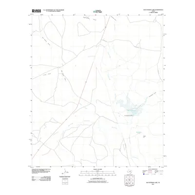
2010 Map of San Esteban Lake
USGS Topo · Published 2010About this map
Alamito Creek defines the drainage patterns of this high-desert landscape in Presidio County, flowing through a series of rugged draws and hills. The central hydrological feature is San Esteban Lake, held by the San Esteban Lake Dam, which captures the intermittent flows of the surrounding basin. This early 21st-century survey illustrates how water management shapes the arid terrain, with numerous named drainages such as Big Trestle Draw, Saucito Creek, and Julia Creek converging in the area. Access to this remote ranchland is maintained through secondary routes like Ranch Rd 169 and Mitchell Rd. The topography is marked by distinctive elevations including Rancheria Hills to the north and Tinaja Hill to the east, indicating a landscape of significant relief where cattle ranching remains the primary land use.
Find a feature on this map
15 named features on this map. Tap any name to fly to it.
Don’t see what you’re looking for? This feature index may not catch every label — zoom into the map to look around manually.
Map Details
Editions of this 2010 San Esteban Lake Map
This is the sole edition of this map. No revisions or reprints were ever made.
Other maps of this area

1895 · Marfa
USGS Topo · 1:125,000

1895 · Alpine
USGS Topo · 1:125,000

1954 · Fort Stockton
USGS Topo · 1:250,000

1958 · Fort Stockton
USGS Topo · 1:250,000

1959 · Marfa
USGS Topo · 1:250,000

1965 · Marfa
USGS Topo · 1:250,000

1972 · Nopal
USGS Topo · 1:24,000

1973 · Fort Stockton
USGS Topo · 1:250,000
1983 · Tinaja
USGS Topo · 1:24,000
1983 · San Esteban Lake
USGS Topo · 1:24,000