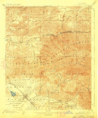
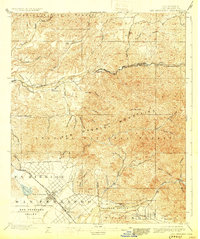
1900 Map of San Fernando
USGS Topo · Published 1924About this map
The San Fernando Mission stands as a focal point of this turn-of-the-century landscape, positioned near the emerging street grids of San Fernando. At this time, the San Fernando Valley remains largely agricultural and open, dominated by the vast land holdings of Ex Mission San Fernando. The transportation network is defined by the Southern Pacific Railroad and its New Orleans Line, which navigate the canyon passes north of the valley.
Find a feature on this map
54 named features on this map. Tap any name to fly to it.
Don’t see what you’re looking for? This feature index may not catch every label — zoom into the map to look around manually.
Map Details
Editions of this 1900 San Fernando Map
6 editions found
Other maps of this area

1894 · Los Angeles
USGS Topo · 1:62,500

1896 · Pasadena
USGS Topo · 1:62,500

1896 · Santa Monica
USGS Topo · 1:62,500

1898 · Santa Monica
USGS Topo · 1:62,500

1900 · Pasadena
USGS Topo · 1:62,500

1900 · Tujunga
USGS Topo · 1:62,500

1900 · Los Angeles
USGS Topo · 1:62,500

1900 · Fernando
USGS Topo · 1:62,500

1901 · Southern California Sheet No. 1
USGS Topo · 1:250,000

1902 · Santa Monica
USGS Topo · 1:62,500