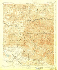
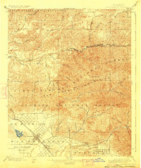
1900 Map of San Fernando
USGS Topo · Published 1930About this map
Ex Mission San Fernando lands dominate the southern portion of this landscape, where the grid of San Fernando is just beginning to take shape alongside the San Fernando Mission. This era reveals the critical role of water and transit in the development of the San Fernando Valley and Tujunga Valley, with the San Francisco and New Orleans Line carving a path through the northern canyons. The survey captures the transition from the valley floor to the high peaks of the San Gabriel Mountains and the Angeles National Forest. Along the Santa Clara River, small rail-side settlements like Lang and Humphreys serve as early markers of industrial movement. Numerous drainages such as Placerita Canyon and Escondido Canyon define the complex topography that would later become synonymous with Los Angeles' northern expansion.
Find a feature on this map
51 named features on this map. Tap any name to fly to it.
Don’t see what you’re looking for? This feature index may not catch every label — zoom into the map to look around manually.
Map Details
Editions of this 1900 San Fernando Map
6 editions found
Other maps of this area

1894 · Los Angeles
USGS Topo · 1:62,500

1896 · Pasadena
USGS Topo · 1:62,500

1896 · Santa Monica
USGS Topo · 1:62,500

1898 · Santa Monica
USGS Topo · 1:62,500

1900 · Pasadena
USGS Topo · 1:62,500

1900 · Tujunga
USGS Topo · 1:62,500

1900 · Los Angeles
USGS Topo · 1:62,500

1900 · Fernando
USGS Topo · 1:62,500

1901 · Southern California Sheet No. 1
USGS Topo · 1:250,000

1902 · Santa Monica
USGS Topo · 1:62,500