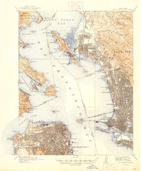
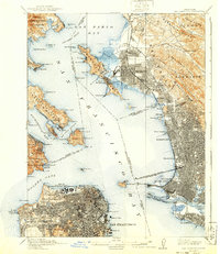
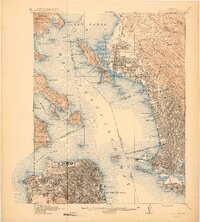
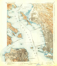
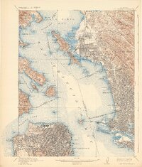
1915 Map of San Francisco
USGS Topo · Published 1947About this map
The Site of Panama-Pacific International Exposition and the Presidio anchor the northern waterfront of San Francisco in this 1914 revision. Across the Golden Gate, the Marin Peninsula remains dominated by the Military Reservation and Fort Baker, while the eastern shores of San Francisco Bay show a dense grid of expansion in Oakland, Berkeley, and Richmond. Significant industrial and transit infrastructure is visible, including the San Francisco-Oakland Terminal Key Route Pier and the Oakland Mole, which served as critical rail-to-ferry links before the era of trans-bay bridges.
Find a feature on this map
131 named features on this map. Tap any name to fly to it.
Don’t see what you’re looking for? This feature index may not catch every label — zoom into the map to look around manually.
Map Details
Editions of this 1915 San Francisco Map
6 editions found

Historical Maps of San Francisco Through Time
14 maps found

1895 San Francisco
San Francisco County, CA

1899 San Francisco
San Francisco County, CA
1915 San Francisco
San Francisco County, CA

1947 San Francisco
San Francisco County, CA

1948 San Francisco
San Francisco County, CA

1955 San Francisco
San Francisco County, CA
1956 San Francisco
San Francisco County, CA

1957 San Francisco
San Francisco County, CA

1960 San Francisco
San Francisco County, CA

1961 San Francisco
San Francisco County, CA

1964 San Francisco
San Francisco County, CA

1971 San Francisco
San Francisco County, CA

1978 San Francisco
San Francisco County, CA

1985 San Francisco
San Francisco County, CA