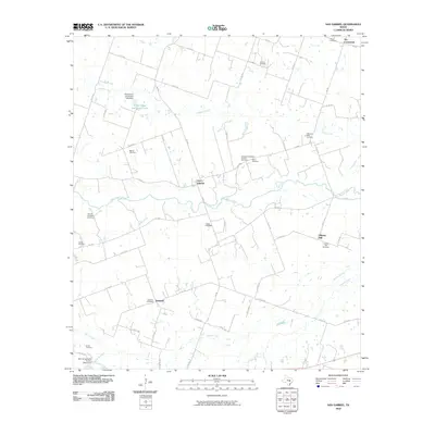
2010 Map of San Gabriel
USGS Topo · Published 2010About this map
The San Gabriel River winds through this Milam County landscape, anchoring a rural community defined by scattered settlements and a deep genealogical record. Small hubs like San Gabriel, Liberty Hill, and Detmold are connected by a network of farm-to-market roads, including FM 487 and FM 486. The map is particularly notable for its density of burial sites, which suggest the early family-based patterns of land ownership in the region. Names such as the John W Hamblen Cemetery, Locklin Cemetery, and Hernando Gonzalez Familia Cemetery offer significant value for family history research. In the northern reaches, Alligator Creek flows toward the river, while Ellett Camp and Glaser Lake provides a localized water feature. The southern portion of the quadrangle is marked by Turkey Creek and Brushy Creek, illustrating the well-watered prairie typical of this part of central Texas.
Find a feature on this map
55 named features on this map. Tap any name to fly to it.
Don’t see what you’re looking for? This feature index may not catch every label — zoom into the map to look around manually.
Map Details
Editions of this 2010 San Gabriel Map
This is the sole edition of this map. No revisions or reprints were ever made.
Other maps of this area

1885 · Taylor
USGS Topo · 1:125,000

1887 · Taylor
USGS Topo · 1:125,000

1894 · Taylor
USGS Topo · 1:125,000

1910 · Buckholts
USGS Topo · 1:24,000

1912 · Buckholts
USGS Topo · 1:31,680

1954 · Austin
USGS Topo · 1:250,000

1962 · Rockdale West
USGS Topo · 1:24,000
1962 · Pettibone
USGS Topo · 1:24,000
1963 · Sharp
USGS Topo · 1:24,000

1963 · Friendship
USGS Topo · 1:24,000