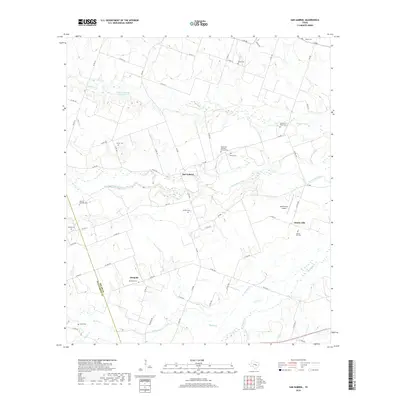
2019 Map of San Gabriel
USGS Topo · Published 2019About this map
San Gabriel and Detmold sit at the center of this rural landscape where the winding San Gabriel River divides Milam and Williamson counties. The map reflects a deeply established agricultural community, evidenced by numerous small family and community burial grounds such as the Hernando Gonzalez Familia Cem, John W Hamblen Cem, and Grantham-Miles Cem. The terrain is defined by a dense network of tributaries including Alligator Cr, Pecan Cr, and Brushy Slough, which drain the surrounding farm and ranch lands.
Find a feature on this map
61 named features on this map. Tap any name to fly to it.
Don’t see what you’re looking for? This feature index may not catch every label — zoom into the map to look around manually.
Map Details
Editions of this 2019 San Gabriel Map
This is the sole edition of this map. No revisions or reprints were ever made.
Other maps of this area

1885 · Taylor
USGS Topo · 1:125,000

1887 · Taylor
USGS Topo · 1:125,000

1894 · Taylor
USGS Topo · 1:125,000

1910 · Buckholts
USGS Topo · 1:24,000

1912 · Buckholts
USGS Topo · 1:31,680

1954 · Austin
USGS Topo · 1:250,000

1962 · Rockdale West
USGS Topo · 1:24,000
1962 · Pettibone
USGS Topo · 1:24,000
1963 · Sharp
USGS Topo · 1:24,000

1963 · Friendship
USGS Topo · 1:24,000